Muni Ride Log, entry 18: Stevens Trail
Muni Ride Log – Stevens Trail, Colfax, CA (another link to info about it).
I started using the iPhone app “iMapMyRide“. It dumps things back to a website and generates a nice map. Unfortunately, some data points seem to get lost, and it shows straight lines. The ride really took 1:35 mins (roughly), which is right, but I don’t think the mileage is correct. Most sites say 4.5 miles each way, and 9 miles total, which sounds more correct given the time. I rode it on the geared 24 KH muni; mostly in the high gear on the way out ,and in the low gear on the way back.
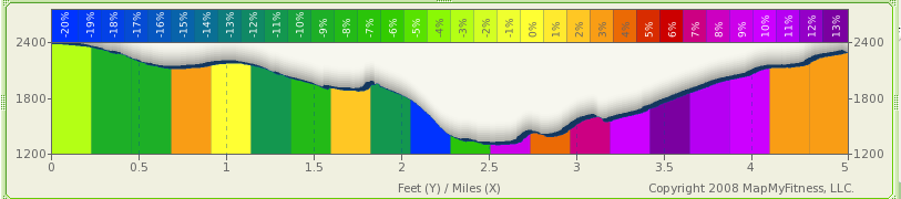
I think the elevation profile (1200′ of loss and gain on the way out) does seem right:
Overall, the program is pretty cool! Especially considering it is free. The thing I don’t like is that the map information (data points) are stored online only; I would like a local copy. Now..only if JR finishes his app.